 |
||||||||||||||||||||||||||||||||||||||||
|
|
||||||||||||||||||||||||||||||||||||||||
Lake Titicaca and SurroundingsLocation: Rediscover Machu Picchu > Peru & the Andes > Lake Titicaca and Surroundings -----------------------------------------------------------------------------------------------------------------------------------------------------------------------------------------------------------------
Introduction to Lake Titicaca
Lake Titicaca is a large lake between Peru and Bolivia. Most of the lake belongs to Peru, the rest to Bolivia. Interestingly, Bolivia maintains a navy on the lake. It has It is a primary travel attraction in the two countries. Foreign
tourists put Lake Titicaca and its surroundings on top of their main
targets. The lake is located at a height of 3.812 m (12,500 ft) and has a surface area of 8.372 km² (3,232 sq mi). The maximum length of the lake is 190 km (118 mi), the maximum width is 80 km (50 mi), making it the largest South American considering the volume of water. It also has a huge catchment area of 58.000 km² (22,400 sq mi). The maximum depth of Lake Titicaca is 281 m (922 ft). The average depth is 107 m (351 ft). Indeed, a very deep lake. The shore length has 1.125 km (699 mi).
The average surface temperature of the lake is 10 to 14 °C (50 to 57 °F). This is pretty much the same the whole year. The lake never freezes, as the temperatures are rarely sub zero and also because it has a large volume of water moving rapidly enough to block freezing.
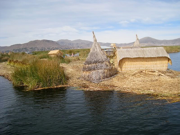
What is particularly interesting is that there are over 40 islands on it, some of which are not natural, but man-made floating islands (!). Lake Titicaca is one of those rare place on earth, where you can see floating man-constructed islands. These are the main tourist attraction to those arriving to Lake Titicaca. The attraction of the lake are presented lower on this page...
The Islands of Lake Titicaca
There are both natural and man-constructed islands on Lake Titicaca. We are taking a look at the most important ones to help you plan your trip!
The Uros Floating Islands
A group of 42 artificial islands. Most often, simply called Uros. These are constructed of floating reeds, namely totora reeds. This plant lives in the shallow parts of Lake Titicaca. The locals have constructed these islands for rather defensive reasons: in case there was danger coming, they could move them away... Homes have been built on these islands and some of them are open to
visiting tourists. Most of them are not, however. You can't just "sail to an island and jump off when there"... Most of them are populated by rather isolated communities, families.
Amantaní
This island is a natural island on Lake Titicaca. It is a fairly large one with about 3.700 inhabitants and 800 families. Only the 1988 statistics are available, which show 3.663 inhabitants, but their number certainly has changed during the last more than two decades...
The area of Amantaní is 15 km² or 6 sq mi. The shape of the island is roughly circular and has two mountain peaks: Pachatata and Pachamama. There are temples located on the top of each peak. These are closed
most of the year to the great public. Entrance is allowed on January 20th
each year, when the annual "feast day" is held. Interestingly for this
ceremony, the island's population splits into two large groups. Some
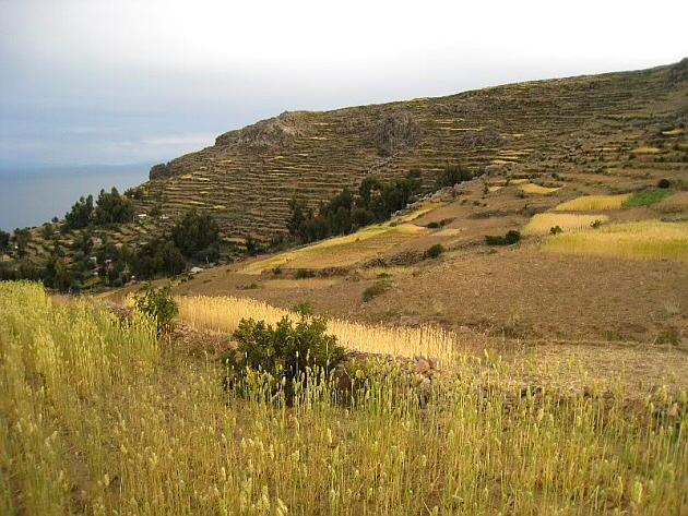
gather on the Pachatata top, others on the Pachamama. For visitors, we can say that the landscape is very beautiful with the dark blue lake, light blue sky and the darker shorelines, as well as the closer large island of Taquile, which are visible in the distance... Not only the views are splendid, but also the island itself, where terraced agricultural techniques are used even today: wheat, quinoa, potatoes, peppers are the primary plants cultivated here. Alpacas and other animals can be seen "walking around" on the island... The locals are famous for their textiles, ceramics and adobe houses. Amantaní is an island where there are no cars... Amantaní is nicknamed "The Island of the Kantuta" (otherwise called Cantuta, Cantua or Qantuta). An orange flower specie widely spread in Peru and Bolivia. It is the national flower of both countries and it can be found in abundance on Isla Amantaní.
It is important to mention that there are no hotels on Amantaní. Families are the ones that host visitors. You will have to travel with an agency to make sure that you are safe and stay at a good place.
Don't expect good roads or even shops on the island. There is a health clinic, some small shops for basic goods. Electricity is available to few on the island and only for a few hours per day, as it is generated by a generator.
Amantaní Island and its golden fields
Taquile
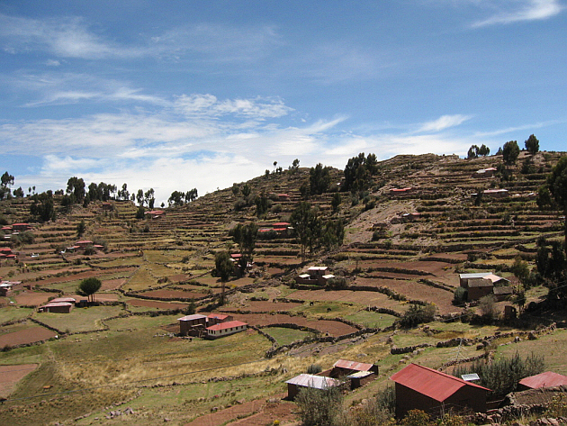
It is a hilly island in the lake, which was used as a prison during the Spanish colonial times and then afterwards until the beginning of the 20th century. The current population of the Taquile Island is around 3.000. The attractions include agricultural terraces, the beautiful views
towards the mainland shores and nearby islands... The island is 35 km (22 mi) away from Puno. The size of the island is 5,5 km x 1,6 km (3.4 mi x 1 mi)... you can walk around and see most of its features in 1 - 2 hours.
The City of Puno and its Attractions
This big city is southeast of Juliaca. It is architecturally more attractive than Juliaca city, but it has no airport and must be reached either by train or road.
Puno is a port city on the shores of Lake Titicaca with beautiful views.
Puno city is considered a linguistical meeting point where Aymara and Quechua speaking Peruvians live. At 3.822 m (12,565 ft) it might feel hard to breathe for the arriving
tourist, especially if coming directly from significantly lower altitude
levels.
The ruins of Machu Picchu are lower than Puno. About 1.400 m
lower! Puno is a cold city and even in the summer it can seem freezing at night to the European or North American visitor, especially. During the day the sunrays are stinging and the heat rises. Protective measures are recommended.
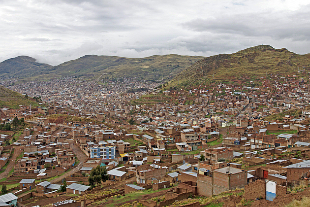
Living quarters of Puno spread across many hills... You might call
this "Puno's suburbs"
The Cathedral
The church looks similar to the Cuzco Cathedral, at first. It has two towers and its architectural design, the two towers resemble the building in Cuzco. This is one, but not the only colonial church. You will find this one
at the Plaza de Armas.
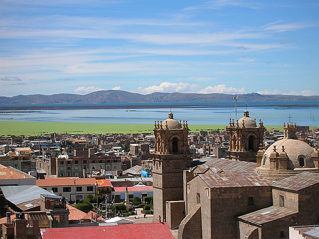
View of Puno from the cathedral towards Lake Titicaca
The City of Juliaca and its Attractions
Juliaca city is in the Puno Region of Peru, west of Lake Titicaca, northwest of the city of Puno. It has about 220.000 inhabitants and it is located at a height of 3.825
m from sea level, on the Collao Plateau, which is part of the Peruvian
Altiplano. It is the only civil and commercial aerial gateway to the Lake Titicaca
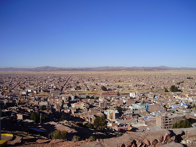
area through its Inca Manco Cápac International Airport. There are few important spots in Juliaca, which is a crowded city of mostly small buildings. Look on the image below... this is Juliaca... Clear blue sky, a city located high on the Altiplano where it is hard to breathe due to oxygen scarcity... Full of buildings, brownish-grey city.
The Juliaca Cathedral (Santa Catalina Church)
There is a small light grey coloured church with rather unusual architectural forms... It has strange arches, a single tower and a smaller wider cupola on the other end and looks like it was put together by adding annexes during a longer period of time.
It is a very beautifully designed church containing fine details. Santa Barbara Convent
This is a modern building following older architectonic styles with its round arches, with elements borrowed from ancient castles.
Sillustani
Pre-Incan archaeological site. It is considered to be the remains of a burial site. A place dedicated to the "other World", to the dead. Tombs have been built above the ground in the form of chullpas,
which are rounded stone towers. The Colla people had constructed Sillustani. Then the Incas have
conquered them in the 1400s. It is suggested that the Collas were the
ancestors of the Aymara people. The tallest chullpa has 12 m. Unfortunately most of these towers have been demolished or severely damaged by grave robbers. In fact, the grave robbers have inflicted more damage than the conquistadores on these structures.
The stones used in construction have straight edges, straight lines. Yet, another mystery... Nobody knows how they were cut.
Pucará (Pukara) and its Attractions
This is a small town close to Juliaca, located on higher ground, northwest, towards Cuzco. It has no railway line, but it can be reached by poor road, if you rent a vehicle or take a bus. It will take 60 km (37 mi) to get from Juliaca to Pucará on road.
Today, close to 7.000 people live in the town.
The meaning of its name is fortress. And the town must not be confused with the Inca ruins of Puca Pucara, located in the vicinity of Cuzco.
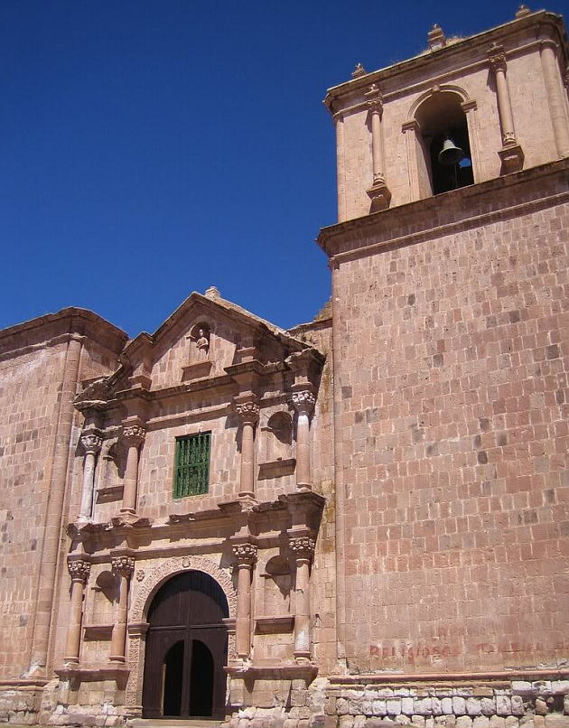
The main attraction of Pucará is its colonial church. It has a beautiful facade, but is no match to the church located in Lampa. If you have to choose between Lampa and Pucará, then we recommend you to check out Lampa!
Pucará is surrounded by massive cliffs, which add more excitement to the scenery. The area is semi-arid, partly grass-, partly sand-covered. In the proximity of Pucará you will see a number of rectangular rocks, which are believed to be the remains of an ancient pre-Incan building. Most probably a complex containing temple(s), military dwellings too. The site is literally a field covered with rocks, many of which are put together in a square shape. No complete buildings, nor walls are intact.
The colonial church in Pucará
Lampa and its Attractions
The town has about 5.000 inhabitants and is located 35 km (22 mi) from Juliaca and 65 km (40 mi) from Puno cities. You can get there by road vehicle only. On the main road from Puno you will most probably go through Juliaca.
You will pass beautiful scenery, hills, lakes, rivers, until you will
enter Lampa, located behind a small group of mountains. The Iglesía de la Inmaculada Concepción is a wonderful building, even when compared to other Peruvian churches! From outside it looks more beautiful than any other church in Cuzco! Compared to the fantastically beautiful old, ornamented colonial church, the town is very small. The streets have very simple, worn-down buildings.
Chucuito and its Attractions
18 km (12 mi) from Puno, Chucuito is another small town that packs some attractions for travelers visiting the Titicaca Lake area... It is a Titicaca lakeshore town. Located on the road that leads into
Bolivia. Chucuito is a small Aymara town. It used to be an Inca settlement and
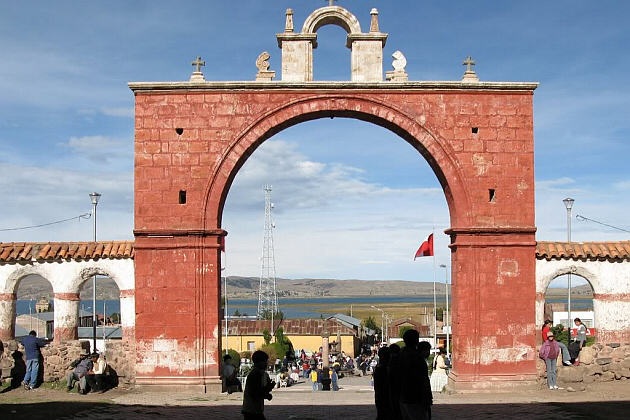
was the capital of the province. The main attractions of Chucuito are the Inca Uyo or the Templo de la Fertilidad (Temple of Fertility) - which is a complex containing phallic objects, the Plaza de Armas with a reddish arch, the renaissance Nuestra Señora de la Ausunción church and the Santo Domingo church. The Templo de la Fertilidad is an Inca archaeological complex where phallic sculptures can be found. You might think they are stone statues of mushrooms... wrong! These stone phalluses were placed in such a way that they point to the sky. Strangely the stones have survived the Spanish colonial period.
Chucuito: red arch in the Plaza de Armas
The Natural Habitat Around Lake Titicaca
Puya Raymondi is a renowned plant widely spread in this area of Peru. West of Lake Titicaca you will encounter these unique plants on vast semi-desert hilly areas.
Getting to Lake Titicaca
Juliaca has and airport to which you can arrive from Lima, Arequipa and Cuzco (Cusco).
Trains go through Juliaca and each Puno. At Juliaca, part of the railway lines go south to Arequipa. So, you have train connection with the Titicaca area from Cuzco and Lima, train stations being located both in the city of Puno and Juliaca. Most travelers arrive in from Cuzco by train. Usually there are 3 trains weekly through Juliaca and into Puno. Cuzco to Puno or Juliaca by train is of course, from which you will get to see the beautiful scenery. Train trips more comfortable than bus trips. You should get prepared to pay 230 - 250 $ for a single train trip from Cuzco to Puno! Very expensive!
By road you can also reach Puno, Juliaca. There are many buses from Cuzco and Arequipa. There is a main road connecting Bolivia with the lake area, running
south of the lake. This road takes you to or from Bolivia, connecting with
Juliaca and Puno. |
|
|||||||||||||||||||||||||||||||||||||||
|
|
||||||||||||||||||||||||||||||||||||||||
|
|
||||||||||||||||||||||||||||||||||||||||
|
|
||||||||||||||||||||||||||||||||||||||||
|
||||||||||||||||||||||||||||||||||||||||
|
|
||||||||||||||||||||||||||||||||||||||||
